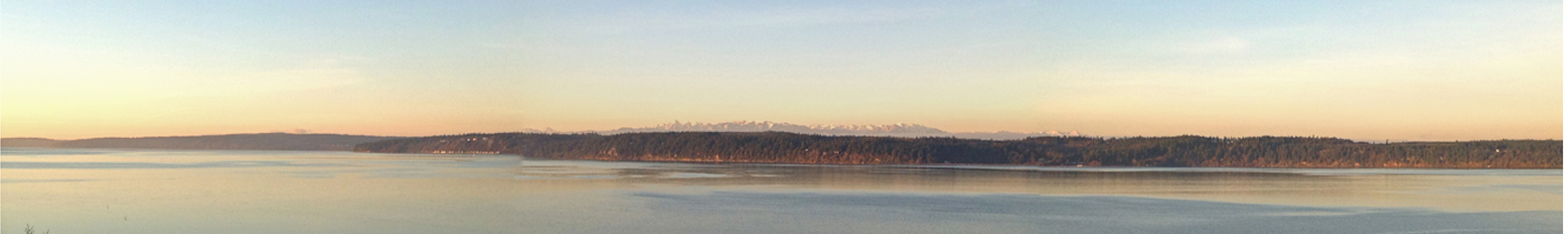
 Camano Island Weather
- Camano Island, WA
Camano Island Weather
- Camano Island, WA
Updated: 11:18pm on 7/26/24
|
|
|
Camano Island Weather
- Camano Island, WA
|
|
Updated: 11:18pm on 7/26/24 |
| Temperature | Wind | Rainfall | Barometer | Solar / Lunar |
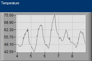
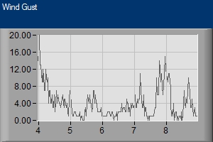
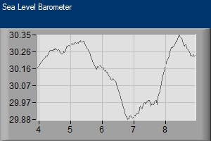
| Current Temp: 55.9 ° ....feels like 55.9 ° | Current Wind: 0 mph NNW | Today's Rainfall: 0.00 in | Current Reading: 29.93 in / (Steady) | Sunrise: 5:41am |
| Yesterday @11:18pm 56.2 | Current Gust: 4 mph | Hourly Rainfall: 0.00 in | Hourly Rate: -0.004 | Sunset: 8:55pm |
| Today's High: 80.4° @ 4:37pm | 10 Minute Average: 0 mph | Month-to-date Rainfall: 0.01 in | Today's High: 30.21 in / @ 12:00am | Moon Percent: 62% |
| Yesterday's High: 80.0° @ 5:00pm | Today's High Gust: 10 mph @ 2:36pm | Year-to-date Rainfall: 15.76 in | Today's Low: 29.93 in / @ 10:54pm | Moon Rise: 11:28pm |
| Today's Low: 52.0° @ 5:36am | Yesterday's High Gust: 25 mph @ 12:00am | Yesterday's Rainfall: | This Year Low: 29.26 in / on 3/2/24 | Moon Set: 12:24pm |
| Yesterday's Low: 55.3° @ 11:59pm | Interactive Ventusky Weather Map *NEW* | Days Without Rainfall: | Current Impact On Tides* = |
| Everett and Vicinity Advisories | Northern Inland Waters Advisories | East Entrance Straits of Juan de Fuca Advisories | Admiralty Inlet Marine Advisories |
|
|
|
|
|
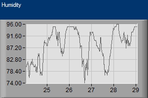
| Temperature | Wind Gusts | Sea Level Barometer | Humidity | Rain Rate |
|
|
|
|
|
| KING | KIRO | KOMO | |
|

|

|
|
| Animated Satellite | Coastal Radar | North Sound Radar | National Satellite/Radar |

|

|

|

|
| Camano Island Tides | Marine Traffic |
|
|
| University of Washington | Weather Station Data | Miscellaneous Travel And Weather Links |
| Cliff Mass Weather Blog | Weather Underground Station History | Seattle Traffic Map |
| University of Washington Radar | Mobile Device Page - *New* | Canadian Border Traffic |
| Storm King - History of PNW Storms | Snoqualmie Pass | |
| National Weather Service | Local Personal Weather Stations | Stevens Pass |
| NWS Discussion - Seattle | Skunk Bay Weather | Weather Along I-90 |
| National Weather Service Marine Forecast | Current Weather Conditions Map | Santa Cruz, Ca. |
| NWS Western Washington Warnings | New York | |
| Local Media News Weather Links | Local Recreation Links | Misc. Weather / Environment Links |
| Scott Sistek Weather Blog | Camano Island Tides | State Ferry Weather |
| KOMO TV Weather | Shellfish Closures (Text Version) | NOAA Buoy Data |
| KING TV Weather | Orca Network | Earthquake Data |
| KIRO TV Weather | WSDF Poaching Hot Line | National Weather Map |
| KCPQ Weather | Camano Island Tides - NOAA | PUD Power Outage Map |
|
|
Wind Predictions | |
| Earth Wind Map | ||
| Live Air Traffic Radar | ||
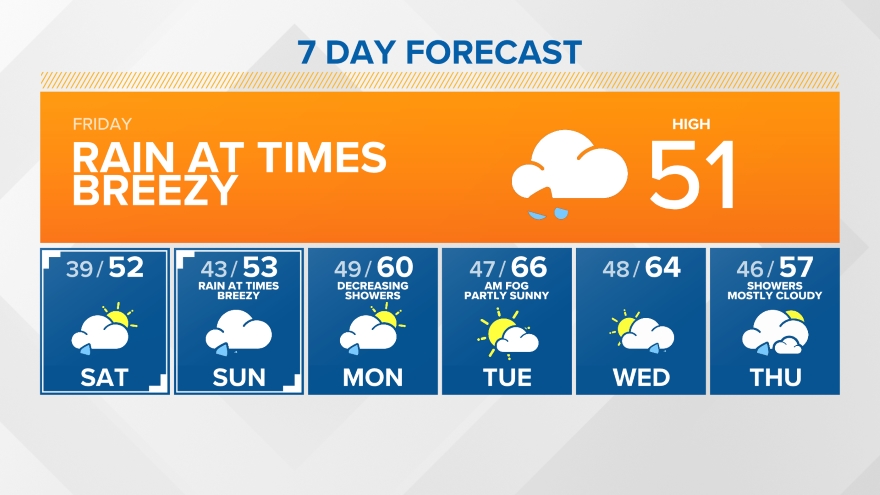
| Interactive Wind Map | NWS 7 Day Forecast ----- Temporary Link To NWS 7 Day Forecast ----- |
|
|
Website Designed By SkunkBayWeather.com  |